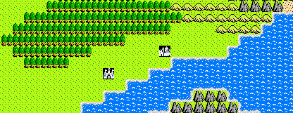
 Above is a selection from the wilderness map created for "The Endless Stair," a TSR module for 1st edition Dungeons and Dragons originally published in 1987. Prior to the release of third edition D&D by Wizards of the Coast, maps such as this were commonplace. With that release, for reasons unknown to me, Wizards of the Coast apparently thought it was best to completely sever the connection between D&D and the noble hexagon. As a tabletop role player who started with D&D 3.x, I spent a number of years vaguely aware that some people liked hexes, but had to context as to how they could be beneficial.
It was Trollsmyth's superb series of hex mapping posts which finally drove home for me the importance of hex maps. They are not intended as a replacement for maps constructed using squares, but rather, are intended to supplement those maps in situations where squares are less appropriate. Squares work best for dungeons and other structures, where walls and rooms and corridors often snap neatly into a square grid anyway. In fact, the module I mentioned above, The Endless Stair, contains a number of dungeon maps printed on a square grid.
What hex maps are intended for is the outdoors. Squares have no place measuring nature. If any of my readers are old enough to have played the original Dragon Warrior
 game for the NES, they know what I mean. The game was great fun, but the squared-off overworld map looked silly even in those days of primitive technology. And while the righteous hexagon may not necessarily be a more 'natural' shape, it certainly approximates a natural shape more efficiently than its brutish cousin the square. Through the use of its two additional sides, the hexagon is more uniform in size than the square. The the distance between the center of a hex, and the center of any adjacent hex, is equal for all six sides. Whereas the square, with its 8 adjacent spaces, allows characters to travel much greater distances when moving diagonally than when moving up, down, left, or right. The only way to compensate for this extra distance is to penalize a character somehow for moving diagonally. And while this may be a simple matter on a small scale map (each space moved diagonally is counted as 1.5 spaces.), it becomes more difficult on a larger scale.
Which brings us to the next point regarding hexes: scale. Maps of dungeons or other areas which utilize squares are generally done on a small scale. The most common measurement is that 1 square is equal to 5 square feet. It's simple, and when a room is only thirty feet square, it's effective. However, wilderness travel require a larger scale by definition. No one in their right mind would try to map a forest, a mountain range, or a continent, in five-by-five foot increments. To even attempt it would be ludicrous. The standard size for a single hex on a wilderness map is six miles across from flat side to flat side. While a GM can use any scale he or she pleases, the six mile scale has a good balance. It's small enough that overland travel can be measured in a meaningful way (with most characters being able to travel between 12 and 18 miles in a day), but large enough to allow a good sized continent to fit on a piece of 8 1/2 by 11 graph paper.
The largeness of a six mile hex comes with other benefits as well. At over 30 square miles*, it's impossible for a party to fully explore every hex. They can mark down the primary terrain, and any items which they come across, but there will always be more. This means that even a hex which has already been explored can offer new challenges for players. From wandering monsters which they didn't encounter the last time, to dungeon entrances, or perhaps an entire community or fortress which was 2 or 3 miles away from the route the party took last time they passed through. The blog "I Waste the Buddha With My Crossbow" has a great post which gives you an idea of just how large this scale is.
For all the arguments I can make demonstrating the benefits of hex maps, there's one which I keep returning to time and again. An argument which, in my mind, is irrefutable proof that the D&D community needs to re-embrace hex mapping:
We don't have anything better yet!
It baffles me why Wizards of the Coast would abandon a perfectly good system without at least attempting to provide a replacement for it. But they did nothing of the sort! Wilderness travel was downplayed significantly in 3.x, and that hasn't been remedied in Pathfinder. On the rare occasion that wilderness maps are included in adventure modules, the best they can do is indicate scale with a measuring stick. Take a look at this map from one of my favorite D&D 3.5 modules, "The Standing Stone:"

What about this map is improved by the lack of a hex overlay? Nothing! Refusing to include an overlay of mighty hexagons forces the GM to add measuring tape to the already cluttered area behind the GM screen. And while it may be argued that the map is too small in scale for six-mile hexagons to be of use, I would reply that the map is perfectly scaled for three-mile hexagons. Wizards of the Coast had better options. Options which they chose to ignore for reasons I cannot even begin to guess at.
Hex maps provide us with the metric which makes world exploration possible. Without it, completely open-ended, sandbox exploration can seem like a daunting task to players and GMs alike. I know I certainly never had the guts to provide a world exploration game to my players before I learned about Hex mapping--despite being very proud of the maps I'd created! Nor have I ever been given much choice as a traveling player. Travel is always handled by indicating where I'm going, and then fading to black as I travel there. And you know what? That's sad.
As the old saying goes: "The journey is more important than the destination." Isn't that the essence of an adventure?
*Yes, I am aware of the irony of using square miles as a measurement in a post decrying the use of squares as a unit of measure. Stop mocking me!
Actually hexagons are more natural than you might think. They are what happens when circles or sphere's are pressed together and forced to tessellate. Just look at honeycomb. Or a bubble matrix. Or sunflower heads.
ReplyDeleteCurrently I'm happy using a ruler, since the primary method of movement in my campaign is seatravel and thus speed varied greatly depending on wind conditions. I'm considering hexes though, and have a version of my map with a hexagon overlay.
@Dan I hadn't thought of honeycombs, that's true! Thanks for the correction.
ReplyDeleteA game can certainly get by with a ruler, I've done it occasionally myself. But I wrote above, I don't see what we gain by *not* using hexes. Measurements only become easier when you can count out grid spaces.